


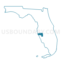
CDD09-Voting District, Manatee County, Florida
About
Outline

Summary
| Unique Area Identifier | 555097 |
| Name | CDD09-Voting District |
| County | Manatee County |
| State | Florida |
| Area (square miles) | 1.03 |
| Land Area (square miles) | 1.03 |
| Water Area (square miles) | 0.00 |
| % of Land Area | 99.75 |
| % of Water Area | 0.25 |
| Latitude of the Internal Point | 27.39397690 |
| Longtitude of the Internal Point | -82.45907330 |
Maps


Graphs
Select a template below for downloading or customizing gragh for CDD09-Voting District, Manatee County, Florida


Neighbors
Neighoring Voting District (by Name) Neighboring Voting District on the Map
- 108DSV-Voting District (Del Sol Village (108 & 17)), Sarasota County, FL
- 112LWR-Voting District (Lakewood Ranch (112 & 154)), Sarasota County, FL
- 115-Voting District, Manatee County, FL
- 72MDW-Voting District (The Meadows (72 & 115)), Sarasota County, FL
- 76-Voting District, Manatee County, FL
- CDD34-Voting District, Manatee County, FL
Top 10 Neighboring County Subdivision (by Population) Neighboring County Subdivision on the Map
Top 10 Neighboring Unified School District (by Population) Neighboring Unified School District on the Map
Top 10 Neighboring State Legislative District Lower Chamber (by Population) Neighboring State Legislative District Lower Chamber on the Map
Top 10 Neighboring State Legislative District Upper Chamber (by Population) Neighboring State Legislative District Upper Chamber on the Map
Top 10 Neighboring 111th Congressional District (by Population) Neighboring 111th Congressional District on the Map
Top 10 Neighboring Census Tract (by Population) Neighboring Census Tract on the Map
- Census Tract 27.13, Sarasota County, FL (8,152)
- Census Tract 12.01, Sarasota County, FL (7,129)
- Census Tract 8.10, Manatee County, FL (5,577)
- Census Tract 12.04, Sarasota County, FL (3,954)